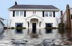
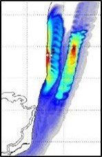
Damages resulting from flooding events are often subject to litigation in which property owners, insurance carriers, and regulatory and legislative entities quarrel about responsibilities for the sustained damage. In this case it is helpful to reconstruct the flood event. The goal is to track water levels and flow paths of water over time for the entire duration of the event to maximum levels, exposure time, and especially volumes of water and their origin (flow paths). With these items known we can identify if flooding was caused because of a failure to provide proper diversions upstream, if flood control structures failed to perform, or if there is no fault at all because of the occurrence of an extreme event. We carry out flooding simulations both in the urban (sewershed), and semi-urban/rural (watershed) environments using a wide variety of tools, such as:
- numerical models that mimic hydrologic processes in the rural environment (e.g. SWAT, HEC-Family, WRF-Hydro, BASINS, and WMS with integrated GSSHA)
- numerical models that are capable of addressing the surface and subsurface urban conveying systems and their coupled nature (SWMM) in addition to high resolution elevation data sets (LiDAR).
- sensor data integration that test the accuracy of our models.
- usage of rainfall data from NASA, NOAA's Weather Services and River Forecast Centers.
- USGS data sets for topography and data from their Nat'l Water Info System on river stages.
- USDA land cover and soil data from USDA to complete our model data set up.
Our standard products include time histograms of flood levels at specific locations, maps depicting detailed flow paths, residence times of water volumes, in addition to inundation maps. We can also customize data products, such as compound maps using transparent layer overlays.
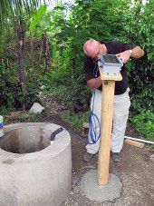
Measuring state variables on location is often the preferred method of obtaining the data needed to assess and analyze hydrologic conditions. We measure solar radiation, soil moisture, wind speed and direction, rainfall intensity, relative humidity, and air temperature in addition to groundwater levels, such as shown in this image. Here the water level is measured via a submerged pressure transducer; logged every hour, and then transmitted via satellite unit every 6 hours to our central server. We are working with a variety of sensor producers but also strive to look for the most suitable solution we can find on the burgeoning sensor market taking into account reliability, cost, and constraints (such as environmental stress), to provide cheapest solution possible.
We also aspire to deliver end to end solutions, i.e. from deploying a sensor to transmitting its data to a secure server, to storing the data (QC'ed) into database for which we provide end user clients. Our motto is to use only non proprietary software components to keep our solutions at a cost minimum. More specifically we:
- work with sensor producing companies such as CSI, INW, Decagon, and Davis.
- use our craftsman skills to build custom made support platforms if needed
- engage in using technology partners such as Upward Innovations for our transmission needs
- engage and train local staff to maintain a minimum effort of maintenance and oversight.
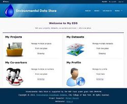
If so desired we are able to add to end user services such as data management solutions to the chain of data progression. These include databases installations, ways of submitting data into the store using workflows, end user appliances that can be used to access and retrieve the submitted data, and also the development of web portals for user access.
Data collection does not end the moment the data logger has stored a data item. This first step needs to be accompanied and followed by several additional steps so the data can eventually be published. These steps include the transmission from the station to a base station from where it can be downloaded via laptop (the simplest solution), to establishing a dial-in connection to a cellular network (thus using the internet for data transmission), to establishing a satellite link up (in case no cellular network is available). Once the data has been received it needs typically needs to be quality controlled before it can be annotated with metadata and subsequently be submitted to a data store. Once in the data store it can be searched, discovered and retrieved in user specified formats. More specifically we provide the following services:
- establish and install the necessary transmission connections: cellular, satellite, or local via download.
- customized scripts (Python) to extract data from download server and submit to local database
- provide workflows for QA/QC in addition to metadata annotations using standards; SensorML
- open source data-store installations such as: CUAHSI ODM, CLIMSOFT, MWATER
- web service support for programmatic access (WaterOneFlow, SOS)
- end user appliances such CLIMABILITY Portal, TimeSeriesAnalyst, HydroDesktop
We strive to use open source software as much as we can to make sure to keep costs to a minimum. We also help installing these appliances in locale in case this becomes necessary and also can provide training sessions to get researchers familiarized with the software.
Water quality is an aspect of water resources protection that is often uncertain and not sufficiently addressed. Especially in developing countries there is often only anectodal evidence that "water is bad" as it causes sickness mostly in the gastrointestinal tracts. While other aspects concerning water can often be seen by the naked eye, contamination is often "invisible" thus contributing to uncertainty towards water resouces, even if they are in abundance.
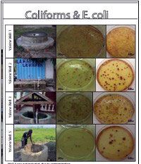
Many times a general good understanding of the local "water situation" is accompanied by a lack of and pervasive ignorance towards even a basic WQ understanding. We engage in Water Quality data collection from wells and streams using field kits that allow us to collect samples in the field and analyze them on the spot (or home base) using small and portable devices thus providing mobility and flexibility. While we anayze our samles for water temperature, pH, hardness, salinity, and TSS as a standard, we can also address metals, nutrients, and chlorine in case these are indicated for. Because in developing countries the use of pestizides is not common and also chemical and heavy industries are not present in large numbers, especially not in rural areas, we mostly focus our water testing on biological contaminants such Coliforms and E.Coli and can also add tests for waterborne diseases such as Cholera.
- we test for common water parameters such as pH, temperature, hardness, and TSS
- we have portable incubators that allow us to grow colonies for example for E. Coli
- we can test for metals and desinfectants such as chlorine
- we can test for dissolved oxygen and nutrients, such as phosporus and nitrates
- we compare with common WQ standards and asses results for recommendations on consumption
We can analyze our samples within 48 hrs (incubator time) and also create detailed reports on the sampled data that gets reported via metadata fields. While we can forward these data via simple EXCEL spreadsheets we are also able to provide sample-data storage solutions, i.e. a database specifically designed for this type of data.
Often a detailed assessment of the geospatial and temporal distribution of contaminants can only be achieved through the use of numerical models that mimic the real (aquatic) world. Numerical approaches are particulalry helpful when the need arises for "what-if" scenarios testing. These include geospatial and temporal invariant loadings, but also the use of extreme climatological events to examine the impact of these events on the fate and transport of pollutants in the water over time. Especially in water bodies that are never really at steady state such as estuaries or river ocean confluences that are subject to tidal changes the cyclic transport of plumes in a "back-and-forth" motion (or pumping) makes it almost impossible to predict where contaminants or sediments end up with what sort of concentrations.
We deploy a suite of hydrodynamic and coupled WQ numerical models to aid in understanding how pollutants spread in the water, and to predict pollution concentraiton levels for predictive purposes, for example regulatory needs addressing discharge permits. We do this through using a number of models that deploy with 1D, mostly 2D, and in some occassions 3D approaches for simulating pollutant and sediment transport:
- we deploy 1D models such as EFDC1D for hydrodynamic and sediment transport simulations
- we deploy 2D models in steady and unsteady mode, such as EPA's HSCTM-2D model
- we deploy WQ models such as WASP and CE-QUAL-ICM that can be run in 1D, 2D, and 3D modes and be coupled to EFDC
- we use pre- and postprocessors for grid generation and visualization of results (JANET, EFDCView), or modeling environments such as SMS (Aquaveo)
- we run models in competing mode and also deploy ensemble runs (mostly climate scenarios) for better calibration and uncertainty assessments
We have the ability to use high perfromance computing facilities through academic partnerships hence are able to address very large scale problems. We can produce time series plots, contour maps, overlaid maps, and also integrate imagery and satellite rasters.
Water resources are increasingly becoming subject of public concern and regulatory action. While in arid and semi-arid regions access to fresh water resources has long been a crucial issue (water rights), even in water rich regions access to and sufficient supply of water are more contested. Inter-watershed transfers are inreasingly more difficult and the realization has set in that watersheds must be the suppliers of the water needs of the people living in them. Especially in developing countries access to sufficient and reliable potable water supplies is underdeveloped. In the absence of technological capabilities to harvest, treat, and move water around over long distances it is even
more crucial to embrace the need to acknowledge all stakeholders, their needs, and how to distribute the available water in equitable amounts such that the sources within the watershed are not depleted. We provide:
- assessment of the water budget through integration of all input sources such as rainfall and GW extraction and output processes such as evapotranspiration, runoff and streamflow, and recharge.
- we deploy watershed models to trace the stores and resident times of water
- we actively work with the local constituencies to evaluate and determine their needs and preferences via stakeholder meetings and charrette type workshops
- we conduct teaching and training workshops on sustainable use of the landscape including the use and protection of water sources
- work together with schools to develop and install teaching modules addressing the interlinkages of ecology, hydrology, economy, and sociology to expand the horizon and raise awareness of the complexity of sustianable development
We have been working together with NGOs that pursue reforestation, waste collection and recycling, in addition to better agriculture practices. We also work with local regulatiry bodies in furthering their technical capabilities in addition to develop long term planning tools to address growing demands and needs that go hand in hand with societal and economic growth